
Stanford University Engineers have designed a hybrid optical-acoustic system, known as the Photoacoustic Airborne Sonar System (PASS), which can revolutionize the way in which the ocean floor is mapped.
By combining understandings from radar and sonar imaging techniques, PASS techniques now allow scientists to map the ocean floor from the air at a faster rate while covering much larger distances than traditional sonar techniques.
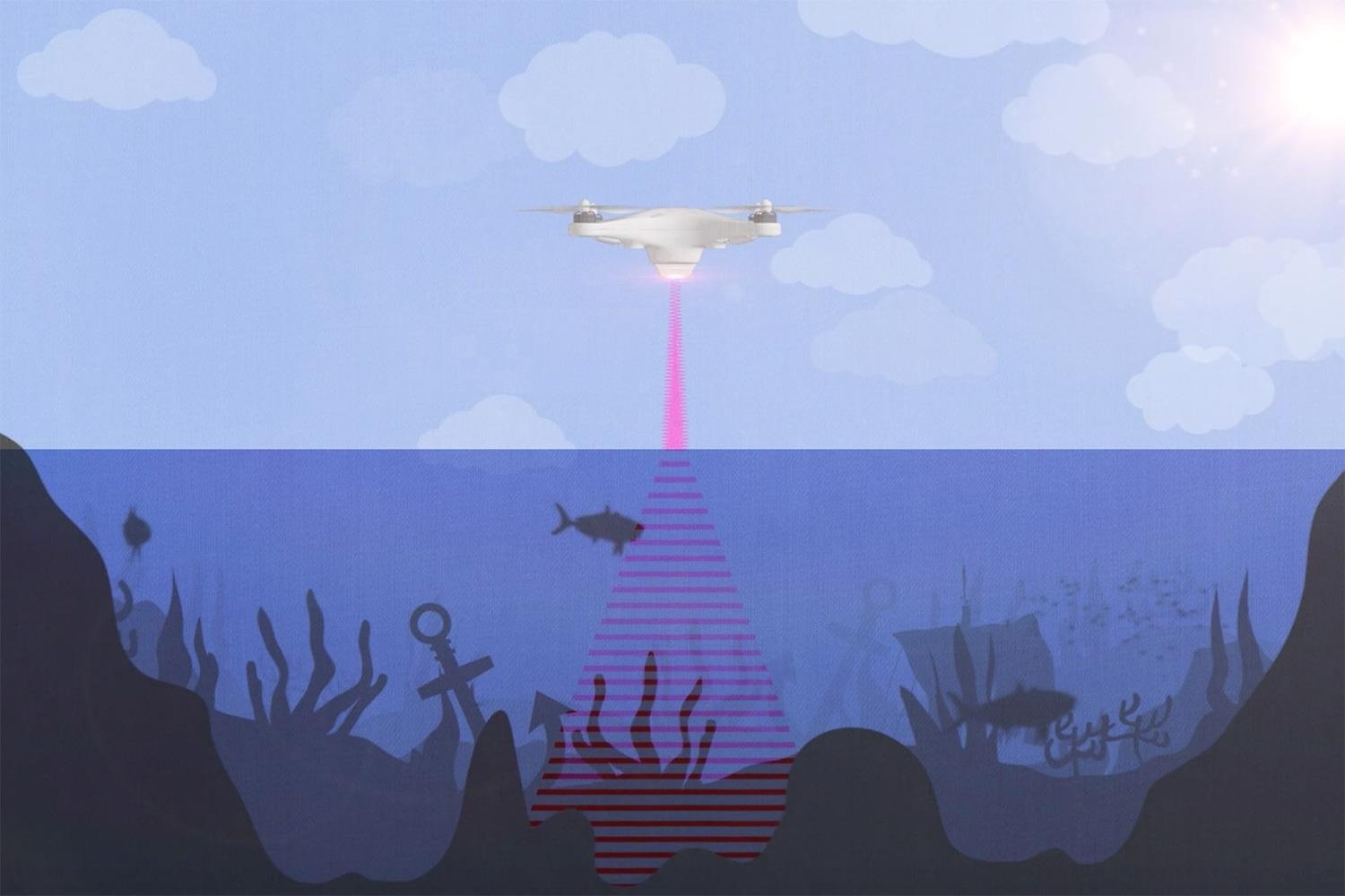
Currently, thanks to modern multibeam sonar systems, only around 5% of the world’s ocean floor has been mapped [1]. PASS techniques fills a gap, where airborne and spaceborne radar systems that have been hugely effective at mapping land are ineffective at mapping the ocean floor as radar signals are either absorbed or reflected by the water surface. Similarly, sound waves that travel from the air into water face the same problem. When sound waves and radar signals hit water surfaces from the air, 99.9% of their energy is absorbed and dissipated by the water, making high-resolution imaging impossible with these techniques alone [2].
The alternative to mapping the ocean floor from the air to date has been to use underwater sonar mapping systems attached to ships or other vessels that trawl the ocean. However, underwater sonar techniques are both too expensive and too slow. The Photoacoustic Airborne Sonar System overcomes the limitations of underwater sonar, since the mapping device can cover a much larger area due to it having a higher vantage point above the water while being able to move about more freely on a device in the air rather than being attached to a waterborne vessel [3].
This technology would have revolutionary applications in bathymetry, the locating of ship and plane wrecks, defense surveillance, and biological surveying of marine environments such as coral reefs.

The PASS technique works by using light to travel through the air and sound to travel through the water. First, a pulsed laser is fired at the water’s surface from the air. When the laser hits the water, it produces ultrasound waves which travel through the water until they are reflected off an object or the ocean floor back to the surface, where they are picked up in the air using collocated high-sensitivity capacitive micromachined ultrasonic transducers (CMUTs). These extremely sensitive CMUTs can then convert the energy from these ultrasound waves into electrical signals which can then build 3d images of the subsurface topography.
The Stanford engineers who have developed this method have already been successful in the laboratory with small-scale tests involving small bodies of static water, proving that the concept works. Work is currently being carried out on finding the most ideal and commercially viable laser wavelength that generates the best acoustic frequency based on the specific makeup of the water, since tests thus far have been conducted on near-pure water samples.
The next step will involve conducting tests in larger environments with dynamic water surfaces. Aidan Fitzpatrick, one of the researchers working on the project, said on the University of Stanford’s blog that “our vision for this technology is on-board a helicopter or drone. We expect the system to be able to fly at tens of meters above the water” [4].
Notes
- Source: ‘How much of the seafloor is left to explore?’, NOAA Ocean Exploration and Research
- Source: ‘Engineers Blending Light, Sound to See Underwater Floor from Airborne Device’, Interesting Engineering
-
Source: ‘An Airborne Sonar System for Underwater Remote Sensing and Imaging’, IEEE Xplore
-
Source: ‘Stanford engineers combine light and sound to see underwater’, Stanford University Communications


